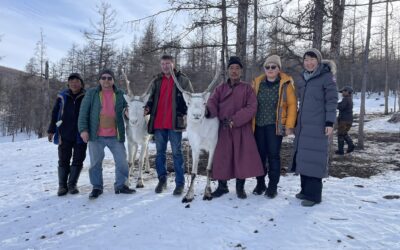
On August 2-19, 2021, the V.B. Sochava Institute of Geography SB RAS’s team of the project “Informal Roads: The Impact of Unofficial Transportation Routes on Remote Arctic Communities (2019—2023)” accomplished its second expedition to the north of Baikal region under leadership of Dr. Vera Kuklina. Participants include Research fellows from V.B. Sochava Institute of Geography SB RAS Irina Bilichenko, Dmitrii Kobylkin, Natalia Krasnoshtanova, and Stanislav Podusenko — photographer and a visual artist.
This project is aimed at detailed interdisciplinary analysis of the overall impact of informal roads on the Arctic environment and economic, social, and cultural wellbeing of local communities. The expected project results will contribute to planning for sustainable development of Arctic and Subarctic regions, which are experiencing unprecedented anthropogenic- and climate-induced changes.
In the framework of the project, the participants conducted field work, that included physical and social geographical research in Nizhneilimsk, Katagan, Ust-Kut, Kazachinsko-Lenski areas in the Irkutsk oblast, and the city and municipality of Severobaikalsk in the Republic of Buryatia.
During the expedition, 3800 km were covered by various transportation methods, including cars, all-terrain vehicles, and boats.


The locals eagerly shared their life stories with the research team about their past experiences and observations. The countless number of gnats and mosquitoes — an integral component of the Taiga — should also be mentioned in this article.
This particular expedition was the first attempt in the four-year-long project framework to combine scientific, artistic, local, and indigenous knowledge and experience. One of the methods of problem-solving used during the expedition was “trial and error”, which still has to be thoroughly reviewed and analyzed.
We knew from past experiences that the roads we would be traveling on were unreliable: new routes appeared, and the old ones vanished almost daily. The streets had gone wild: no road signs, no warnings, no directions, no indications of major crossroads or obstacles. Instead of official markings, one can find a ribbon tied to a tree or something similar that only locals understand and can use for traveling.


In addition to peculiar traffic signs, we realized that respondents called the same point on a known street network differently. For instance, the spot where we were typically picked up by the Irkutsk Oil Company all-terrain vehicle was at the fork in the road, where a new northbound forest trail branched off the main forest road. The employees of a forest company call this point the “MTS mountain” — the spot where the MTS network provider has cell phone coverage (the nearest MTS cell tower is located on the Ichedinsk petroleum reservoir a few kilometers away). The locals, who often interact with the employees of the forest company, have adopted the same nickname for this location. However, the driver of the all-terrain vehicle was startled to hear this version of the name, because he has always known this place as “The cross”, named after the crossroad at that location. “The MTS mountain” — a strategic name of a geographic area covered by the service provider utilized by the people traversing the informal roads. On the other hand, it is an ordinary point for the employees of the oil company, who have access to an uninterrupted network coverage on the petroleum reservoir.
We used high-resolution satellite imagery for orienting in the field. The images were intended to identify the informal roads’ presence and their utilization and analyze the social and ecological consequences of using informal roads. During the first attempt at an interview, it was challenging for a hunter to show various points in his area of operation using one image at a time; we had to upload several photos. We determined that the high-definition images (3 GB each) are backbreaking for our laptops and not ideal for expeditions. However, with the help of our colleagues, we were able to find a solution quickly. Our team used Sentinel imagery, which has lower spatial resolution. These images helped us navigate through informal roads when the driver took the wrong turn at some point during the expedition.
Vera Kuklina, Roads and maps.